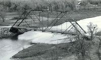
NRHP: Colclesser Bridge
Contents
Colclesser Bridge
NRHP Reference #: 92000729
NRHP Listing Date: 19920629
Location
11 mi S of Rushville, Sheridan County, Nebraska
View this property's location
View all NRHP properties on this map.
Summary
When a massive ice jam carried away the existing bridge over the Loup River south of Columbus in 1886, the Platte County Supervisors immediately began considering a replacement. The following year the county awarded a contract for a bridge consisting of four, 248-foot through trusses. The bridge carried heavy traffic - first as a county road, then the Lincoln Highway and finally on U.S. Highway 30 - until its replacement with another truss, completed in 1933. That August heavy flooding washed out virtually all of the bridges over the Niobrara River in Sheridan County. The Sheridan County Commissioners purchased two of the spans of the Columbus Bridge and erected them to replace damaged structures. Four of the panels were removed from one of the trusses, shortening its span length to 166 feet, and it was erected at the Colclesser crossing, eleven miles south of Rushville.
Further Information
Bibliography
About the National Register of Historic Places
The National Register of Historic Places (NRHP) is the country’s official list of historically significant properties. To be eligible for the NRHP a property must generally retain their historic appearance, be at least 50 years old, and have the potential to be documented as historically or architecturally significant at either the local, state, or national level. The National Register of Historic Places is a National Park Service program administered by the Nebraska State Historical Society for the state of Nebraska. Visit the Nebraska State Historical Society's website to learn more about the program.
