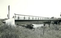
NRHP: Burwell Bridge
Contents
Burwell Bridge
NRHP Reference #: 92000715
NRHP Listing Date: 19920629
Location
N edge of Burwell, Garfield County, Nebraska
View this property's location
View all NRHP properties on this map.
Summary
On June 25, 1939, floodwaters washed out the existing Highway 11 bridge over the North Loup River on the northern edge of Burwell. No effort was made to replace the structure until the following winter, when in March 1940 engineers for the Nebraska Department of Roads and Irrigation designed a new steel bridge. The structure consisted of three steel stringer spans, supported by concrete abutments and piers. With a thirty-degree skew, the Burwell Bridge featured a seventy-three-foot span in the center suspended by cantilevered arms from the outside spans, for a maximum span of 109 feet. The Burwell Bridge represents one of the longest cantilevered beam structures identified in the statewide bridge inventory. It is technologically significant for its representation of long-span beam bridge experimentation conducted by the state engineer's office in the 1930s.
Further Information
Bibliography
About the National Register of Historic Places
The National Register of Historic Places (NRHP) is the country’s official list of historically significant properties. To be eligible for the NRHP a property must generally retain their historic appearance, be at least 50 years old, and have the potential to be documented as historically or architecturally significant at either the local, state, or national level. The National Register of Historic Places is a National Park Service program administered by the Nebraska State Historical Society for the state of Nebraska. Visit the Nebraska State Historical Society's website to learn more about the program.
