NRHP: Sargent Bridge
Contents
Sargent Bridge
NRHP Reference #: 92000740
NRHP Listing Date: 19920629
Location
1 mi S of Sargent, Custer County, Nebraska
View this property's location
View all NRHP properties on this map.
Summary
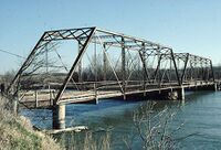
Situated about a mile south of Sargent, this steel bridge carries an unpaved private road across the Middle Loup River. The Nebraska State Engineer delineated the Sargent Bridge in 1908 as two, 120-foot Pratt through trusses carried by steel cylinder piers. The structure was fabricated and built that year by the Standard Bridge Company of Omaha. Later incorporated into U.S. Highway 183, the bridge was abandoned as a public thoroughfare in the 1960s and acquired by the Middle Loup Irrigation District, which currently maintains it for private access to its diversion dam. The Sargent Bridge for decades served as a regionally important river crossing and a gateway to the town of Sargent. It is today noteworthy as one of the oldest surviving structures designed by the state engineer's office.
Further Information
Bibliography
About the National Register of Historic Places
The National Register of Historic Places (NRHP) is the country’s official list of historically significant properties. To be eligible for the NRHP a property must generally retain their historic appearance, be at least 50 years old, and have the potential to be documented as historically or architecturally significant at either the local, state, or national level. The National Register of Historic Places is a National Park Service program administered by the Nebraska State Historical Society for the state of Nebraska. Visit the Nebraska State Historical Society's website to learn more about the program.
