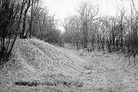
NRHP: Military Road Segment
Contents
Military Road Segment
NRHP Reference #: 93001400
NRHP Listing Date: 19931210
Location
82nd & Fort, Omaha, Douglas County, Nebraska
View this property's location
View all NRHP properties on this map.
Summary
This segment of road, located in Omaha, is significant for its association with the military, road development, and westward expansion. It is part of the old Military Road that originally went from Omaha to Fort Kearny. As such, it was, after 1858, the primary route used by the military to transport supplies between the two points. The road also accommodated the movement of non-military supplies and civilian settlers. The road was first surveyed in 1856 and first came into use in 1858.
Further Information
Bibliography
About the National Register of Historic Places
The National Register of Historic Places (NRHP) is the country’s official list of historically significant properties. To be eligible for the NRHP a property must generally retain their historic appearance, be at least 50 years old, and have the potential to be documented as historically or architecturally significant at either the local, state, or national level. The National Register of Historic Places is a National Park Service program administered by the Nebraska State Historical Society for the state of Nebraska. Visit the Nebraska State Historical Society's website to learn more about the program.
